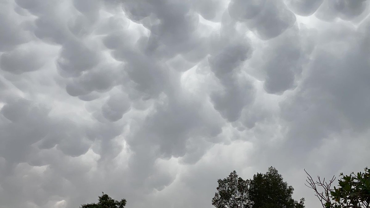
Recently, Qatar's sky showcased the remarkable phenomenon of mammatus clouds, sparking curiosity among citizens who photographed them and questioned their nature and significance. This phenomenon occurs at a time when some countries in the Arabian Peninsula are experiencing thunderstorms, increasing public interest in the reasons behind the appearance of these unique clouds.
Mammatus clouds are among the most visually striking cloud formations, appearing as if the sky is filled with pouches or rounded bags hanging downward. Although these clouds are not a distinct type, they typically appear at the base of certain clouds, especially beneath cumulonimbus clouds, which usually carry heavy rain, thunder, and lightning.
Details of the Event
Mammatus clouds are characterized by their unique appearance, with the term "mammatus" referring to their pouch-like or udder-like shape. In Arabic, these clouds are known as "السحب الضرعية" or "السحب الثديية". These bulges hang down from the base of the cloud, and their formation is due to the presence of cooler air laden with water droplets or ice crystals in certain areas of the cloud. When this air descends into a drier layer, distinct downward pockets form, leading to the emergence of these distinctive clouds.
Mammatus clouds often appear beneath thunderstorm clouds, linking them in people's minds to storms. However, the presence of these clouds does not necessarily indicate that a tornado or severe weather will occur. They can accompany moderate storms, so there is no need for alarm, as they are not conclusive evidence of any immediate danger.
Background & Context
Mammatus clouds typically appear during times characterized by strong aerodynamics, with differences in humidity and temperature and downward movements within the clouds. Therefore, meteorologists view them as a sign that the cloud you see above or near you is an active and complex structure. At a time when Qatar and other countries in the Arabian Peninsula are experiencing thunderstorms, the appearance of these clouds highlights the climatic changes that may affect the region.
It is worth noting that mammatus clouds are not a new phenomenon; they are part of meteorology, which studies cloud changes and their impact on weather. As public awareness of these phenomena increases, so does interest in learning more about the nature of clouds and how they form.
Impact & Consequences
The appearance of mammatus clouds can have multiple effects on the local environment. They indicate the presence of strong atmospheric activity, which may mean that the area could experience weather changes. In some cases, these phenomena may lead to heavy rains or thunderstorms, prompting residents to take necessary precautions.
Although mammatus clouds are not evidence of severe weather, they remain an indicator that weather conditions in the area may be unstable. Therefore, it is important for residents to be aware of these phenomena and to follow meteorological updates.
Regional Significance
Mammatus clouds are part of the weather phenomena that intrigue many in the Arab region, especially in light of the climatic changes affecting weather patterns. With the increase in thunderstorms in some countries, it becomes essential to understand these phenomena and how to deal with them.
In conclusion, the appearance of mammatus clouds in Qatar's sky serves as a reminder of the importance of monitoring and understanding weather phenomena, as they can reflect both global and local climatic changes. Awareness of these phenomena can help enhance public safety and increase our understanding of how weather impacts our daily lives.