The National Center for Meteorology has announced the launch of an advanced service aimed at providing long-term climate data based on satellite technology. This initiative is part of the center's ongoing efforts to enhance climate monitoring and analysis capabilities and improve the early warning system.
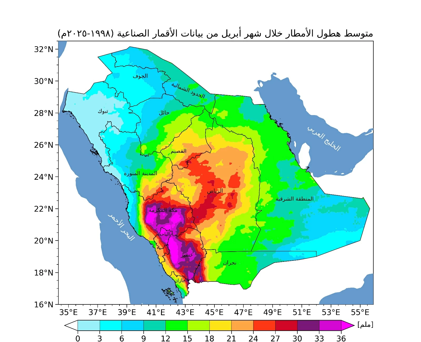
In this context, the center has begun issuing specialized climate maps focusing on rainfall distributions, having released a map for April covering the period from 1998 to 2025. These maps rely on precise analysis of satellite data, allowing for a comprehensive view of rainfall distribution across various regions of the Kingdom.
Details of the Event
The new map shows a concentration of rainfall amounts during April primarily in the southwestern and western highlands of the Kingdom, with lesser extensions towards the central regions. Rainfall is distributed variably across the remaining areas, reflecting the climatic diversity of the Kingdom.
These maps are considered an effective tool in supporting the early warning system, enabling relevant authorities to take proactive precautionary measures. This enhances the level of preparedness to deal with various weather conditions efficiently, contributing to the reduction of potential risks.
Background & Context
This initiative is part of the strategic directions of the National Center for Meteorology, which seeks to provide advanced climate products based on accurate data and reliable scientific analyses. This development is part of global efforts to address climate change, where the importance of precise climate data increases in supporting decisions related to environmental and developmental policies.
Moreover, the use of satellite technology in climate monitoring represents an advanced step reflecting the trend towards innovation in meteorology. This technology allows for the collection of accurate and comprehensive data, contributing to a better understanding of climate changes and their impacts.
Impact & Consequences
These maps represent an important step towards improving water resource management and urban planning in the Kingdom. By providing accurate information about rainfall, relevant authorities can make informed decisions regarding water usage and flood management.
Furthermore, this initiative enhances the level of cooperation between various governmental and private entities in the field of meteorology, contributing to improved responses to emergency weather situations and enhancing public safety.
Regional Significance
In light of the climatic challenges faced by many Arab countries, the launch of these maps serves as a model to be emulated in the region. This initiative can contribute to enhancing regional cooperation in meteorology and the exchange of climate data, strengthening the capacity of countries to confront climate changes.
Additionally, improving early warning systems in Arab countries is vital, especially given the increasing severity of extreme weather phenomena. These maps can help mitigate the damages caused by floods and droughts, positively impacting sustainable development in the region.
In conclusion, the launch of historical rainfall maps is a significant step towards improving the management of climate resources in the Kingdom, reflecting the commitment of the National Center for Meteorology to provide advanced services that support public safety and enhance readiness to face climate challenges.